Kerr County Historical Commission
| |
| home |
| history |
| members |
| markers |
| cemeteries |
| oral histories |
| texas land heritage program |
| archives |
| images of kerr county |
| links |
| friends of the commission |
| contact the commission |
A BRIEF HISTORY OF KERR COUNTY A COUNTY SHAPED BY A RIVER |
||||||||
Kerr County is in a region that has been the site of human habitation for thousands of years. Archeological artifacts found in the area, particularly along the Guadalupe River and its forks suggest that human inhabitants arrived in the area as early as 10,000 years ago. Before the area was settled, the Lipan Apache, Comanche and Kiowa hunted in the region. Dart points, arrow points, fist axes, knives, scrapers and other tools made by early native tribes are found throughout the county. Other remnants left by the early residents of the area are burned rock mounds (piles of varying chunks of limestone which show evidence of fire) and middens. On April 14, 1689, Alonso De Leon (1639 — 1691), Spanish explorer and governor, began exploring westward in Texas. During his exploration he discovered a river or rare beauty lined with giant cypress trees, native walnut and pecan trees. In some places it was a clear stream tumbling over rocks and at other spots it was deep and still. The river rose in the western hills and in places had cut a channel through layers of limestone. De Leon named the river “Our Lady of Guadalupe.” He reported that the banks of the river were covered with good timber. The Guadalupe rises from springs in the northwest part of Kerr County and flows 255 miles to the Gulf of Mexico . Usually, the river flows gently southeastward, but because of its tremendous fall in its first 25 or 30 miles at flood stage it can descend as a mighty wall of water, destroying everything that blocks its path. De Leon ’s discovery was indeed a great one, for the Guadalupe River became the reason for a settlement and through the years it has been a factor in that settlement’s continued existence and growth. During the mid-eighteenth century, Spanish military units traversed the area while defending San Antonio from Apache attacks but it was not until the mid-1800s that the area was settled.
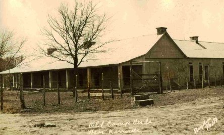
CAMP VERDE While most frontier Army posts of pre-Civil War days were preoccupied with Indians, Camp Verde, 14 miles south of Kerrville, was involved with one of the most remarkable military experiments ever conducted by the US Government. In 1854, Secretary of War Jefferson Davis, later President of the Confederacy, petitioned Congress to appropriate $30,000 so the Army could experiment with camels for army transportation and military purposes. With the support of President Franklin Pierce, the bill was later approved by congress on March 3, 1855. In 1856 Jefferson Davis sent an expedition to Africa to obtain a number of camels to test their adaptability to Texas land and climate. The first shipment of 33 Bactria and Smyrna camels was landed at Indianola, Texas on the naval ship, Supply, in April 1856. They walked to Camp Verde via Victoria and San Antonio - a curious parade for residents along the route. A second shipment of 40 beasts made the trip later. The third shipment, used as a cover for slave importation into the United States, was turned loose to range the coastal country.
CENTER POINT |
Center Point was first called Zanzenberg, after a relative of Dr. Charles Ganahal, who was one of the earlier people to setle the area. The first Post Office was opened November 25, 1859 with Dr. Ganahal as Postmaster in his own home. He kept the office open until the outbreak of the Civil War when he entered the Confederate Army. That was when the Post Office relocated to a picket house in the center of the little town and the name changed to Center Point because the settlement was halfway between Fredericksburg in Gillespie County and Bandera in Bandera County. The settlement was also the halfway point between Kerrville, in Kerr County, and Comfort, in Kendall County. By 1875 Center Point was a thriving community and was larger than Kerrville, the county seat. |
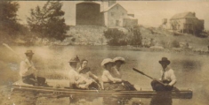
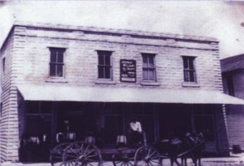 CENTER POINT GENERAL STORE, 1912 |
The area's potential as a farming and stock-raising center, its healthful climate, and its abundant game continued to attract settlers. Virginia Jordan (Wright) de Ganahl, Charles Ganahl's widow, deeded 200 acres to the San Antonio and Aransas Pass Railway in 1888. She hoped to draw the center of population back to the north side of the river around a community to be called Ganahl. Although the community never developed, the Ganahl depot, located a mile north of central Center Point, ensured the town's position as a trade center for the surrounding region.
Center Point held its position as area trade center until the 1920s, when the paved highway skirted the edge of town and surrounding towns developed their own transportation facilities. The town maintained a stable population and business community throughout succeeding years. Much like other towns in scenic Kerr County, Center Point has several small service and manufacturing businesses and attracts a steady stream of vacationers, retirees, and summer residents.
CYPRESS CREEK
The Cypress Creek winds through the hills of southeastern Kerr County, crossing into Kendall County about a mile above its confluence with the Guadalupe River at Comfort. The German farmers who came to this valley of the Cypress Creek made the first organized settlement within the confines of what is today Kerr County.
|
One of the first settlements in what is today Kerr County, the picturesque, originally German-speaking community has been the subject of numerous paintings and many historical, literary, and linguistic studies, as well as an archeological study that suggests that the well-watered valley has been inhabited for nearly 10,000 years. The first two German families, Wiedenfeld and Schladoer, arrived in 1852. Other families and individuals—Saur, Boerner, Steves, Lich, Hoerner, Zink, Lindner, Voigt, Nagel, Nuernberger, Allerkamp, Schellhase, Holekamp, Karger, Mohrhoff, Reeh, and others—soon followed. Linked by kinship, friendship, and politics and bolstered by Reconstruction-era prosperity, a high birth rate, and unusually low infant mortality, the population grew to over 150 within thirty years. |
Many came from New Braunfels, Sisterdale, Bettina, and Kerrville, but some came directly from Europe. There were also English, Anglo-American, and Hispanic settlers. Plans to organize a township never materialized; however, a cemetery, shooting club, militia, and school—but no churches—were established early in the history of this liberal, freethinking community.
A sawmill-gristmill named Perseverence Mill, constructed by Ernst Altgelt in 1855, served both the Cypress Creek community and the adjacent town of Comfort. A women's literary club maintained an active membership for over a hundred years. Droughts of the 1950s and declining agricultural productivity in the 1960s lowered the population to about a hundred. The community grew again in the late 1960s with the completion of Interstate Highway 10, which put San Antonio within commuting distance. Historical markers located on the Sturdy Oak Farm commemorate the cemetery and a nexus of prehistoric sites. German place names abound in the community, including the colorful Hasenwinkel Creek, a small tributary. Among many historic homesteads, the most prominent is the Karger-Keidel ranchhouse (1860s and 1897), which German-Texan architect Albert Keidel inherited and extended between 1945 and 1950, thereby creating the prototype of Hill Country German vernacular architecture later popularized in Fredericksburg, Austin, and San Antonio.
THE DIVIDE
Texas has been historically divided into seven geographic regions. One of these is the Edwards Plateau region in south central Texas, and consisting of rolling hills, canyons and flat areas. The Divide is a rural community located along several miles of State Highway 41 about 30 miles west-northwest of Kerrville in western Kerr County. In the early 1880s settlers homesteaded along this strip of Edwards Plateau noticed this area functioned as a natural dividing line for rainfall run-off. This strip of ill-defined land, 5-15 miles wide, that ran east-west became known as "The Divide." "The Divide" has never been delineated on any map, but it extends, roughly, from Hunt to Rocksprings. The altitude varies from 1800 to 2500 feet above sea level. |
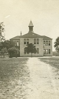
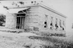
 THE DIVIDE SCHOOL |
Early settlers had to depend on natural wet-weather ponds and dirt tanks dug with a fresno and team for water. When these depressions dried up, there was no choice but to drive cattle to the nearest stream and herd them until the rains came.
The coming of windmills to the Divide, during or shortly after 1880, changed the region into one of the premier ranching areas of Texas. The introduction of barbed wire soon followed the windmill, and the two innovations provided the greatest boom to the production of livestock on the Divide.
Early schools were located on the D. Hughes ranch, alongside the old wagon road from Hunt to Rocksprings, and on the Dietert Ranch, seven miles west of Garven's Store. One of the few remaining one-room schoolhouses, is the Divide School, on the Warren Klein Ranch, located on Highway 41 near the entrance to the YO Ranch.
The Divide has its own fire department, manned by rancher volunteers. There is also a community building, built by Divide residents in 1949.
The Divide is the heart of the Angora goat production in Texas. In addition to goats, sheep and cattle are stocked in the region. Numerous exotic wildlife ranches are found on the Divide today.
HUNT
|
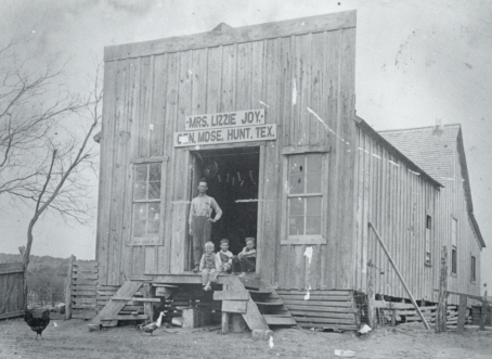
The Hunt community came into being in 1912, when Alvie Joy bought land from his friend Bob Hunt and named the place for him. Alvie then built the store and post office with his home attached and soon the little settlements of Japonica on the North Fork of the Guadalupe River and Pebble on the South Fork dissolved. Hunt was centrally located at the junction of the North and South Forks of the River. Alvie then began to travel to Houston and the Rio Grande Valley to encourage folks to come to Hunt to live. He was the secretary for the first Hunt Booster Club and worked to publicize the area and its healthy climate. The camps for boys and girls came into being in the '20s. Many summer homes were built at that time, as well. In 1932 Hunt proper was washed away in a flood. A temporary building was put up to house the post office and store. Since the 1920s Hunt has served as the center of one of the most popular Hill Country resort areas. The majority of Kerr County's guest ranches and summer camps are located within a few miles of the town; its economy depends on these visitors and on the part-time residents who own the many vacation homes lining the river. |
INGRAM
Ingram is located seven miles west of Kerrville. It is situated on the north bank of the Guadalupe River where Indian Creek runs into the river from the south and Johnson creek from the northwest. Much, if not all, of Ingram was in the John Twohig (assignee of Francisco Trevino) grant of 640 acres from the State of Texas in 1847. After being sold several times, it was acquired by Abner Morriss who sold six acres o the river to J.C.W. Ingram, who in 1879 opened a store and post office. The town was named for him. At the same time Mr. Morriss donated a tract of land for the establishment of a public school and church. From this beginning a town was formed. Main Street in Ingram was originally part of the Old Spanish Trail. In the early days cattle, hogs, goats and sheep were driven right through town in into Kerrville for markets in San Antonio. |
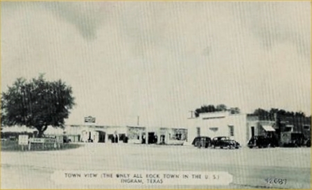 1940s INGRAM |
Early settlers were mostly farmers, raising grain, corn and cotton which was ground and ginned at Sherman's Mill, located at the confluence of Kelly Creek and the Guadalupe River between Ingram and Hunt.
Lumber was also handled by the mill and shingles were made from the cypress trees that line the river. Later, cattle ranching became profitable, after the trails to Kansas were opened, many large herds from this area were sent up the trail.
In later years deer hunting became a business in the area, and still later exoticsqv from several foreign countries were imported for hunting. Beginning in the 1920s, because of the healthful climate and beauty of the Guadalupe River and countryside, the resort business became important to Ingram.
In 1958 the Hill Country Arts Foundation, a nonprofit educational organization that combines art studios and theater for adults and young people, was begun at Ingram.
In June 1981 Ingram went to the polls and incorporated the town. Ingram's first mayr was Donald Oehler. In 1988 the town's population was 1,441. By 2000 the population was 1,740.
MOUNTAIN HOME
Mountain Home, at the intersection of State Highway 27 (this section runs along the Old Spanish Trail) and State Highway 41 in north central Kerr County, was settled about 1856.
The Post Office was established and named by H. Louis Nelson in 1879. The town was called Eura for a brief period in the early twentieth century. In 1923 Olive Estes changed the name to Mountain Home after the beautiful view of Johnson Creek and the surrounding vistas she saw from her front porch.
Mountain Home is the location of the Texas Fisheries Research Station, the Texas Catholic Boys Camp, and the Hill Country Cowboy Camp Meeting. A modern post office stands on Highway 27 and a Volunteer Fire Department building stands nearby.
Sources: Kerr County Album, published by the Kerr County Historical Commission; A History of Kerrville by Anna Belle Council Roland; and Handbook of Texas Online